What is this?
I spotted this mysterious object North of Grantsville Utah.
No one knows for sure where the word, Tooele, comes from. One suggestion is that tooele is a kind of Native American mystical gateway to other dimensions, where alternative worlds may be transcended and explored. In Tooele County, a person doesn't have to travel far to find places where worlds come together. Magickal!
 In November, Dad, Ferrel and I drove the long washboard-ridden road all the way to Stansbury Island on the Great Salt Lake. My butt was sore when we finally arrived at the northernmost point. In the above photo, I am looking West from the furthermost northern tip of Stansbury Island, where land, salten sea and sky optically infuse; to shroud the point where one feature ends, and the other begins.
 What would anyone be doing on an island in the middle of the Great Salt Lake? Stansbury Island is usually a pretty desolate place, but strangely, there was someone else taking photographs off in the distance. I wonder if he got any pictures of us??? Cheese!
 Looking west from Black Rock Beach, Stansbury Island appears to be a world away.
 From Black Rock Beach, (above), to White Rocks, (below), Tooele County is sure to surprise anyone who has his or her eyes open. Even though White Rocks elevation is much higher than that of Black Rock Beach, thousands of years ago, the waves of Lake Bonneville, the ancient predecessor of the Great Salt Lake, worked relentlessly to erode and expose the stone there. Today, White Rocks is a long long way from the Great Salt Lake, but evidence of the ancient lake is easy to see all around.
 There are also places where a more definite line exists. Physical boundaries established by man.
A tall, cable reinforced chain-link fence with barbed wire contains one of Uncle Sam's high-level, top secret research facilities where hundreds of biological and chemical weapons tests have taken place. A few hundred employees and military personnel still keep the vast facility operating.
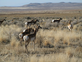
 Outside the forboding fence, antelope run free, with no concern for what happens beyond the very real-life barrier in the desert.
 Any unlucky antelope that happened to be in the wrong place (below) at the wrong time (in 1968) found itself dead among 6000 sheep who mysteriously died from what was determined to be a chemical warfare agent called VX. I wonder where that came from? Unfortunately, aerosolized chemical weapons don't always respect physical boundaries.
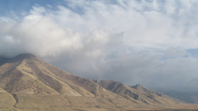
A powerful ascension motif, the mountains rise from the flat valley and extend up to meet the heavens. I shot this photo one afternoon in late November as the sun peeked beneath the clouds to illuminate the west-facing slopes of the Oquihr Mountains east of Lincoln (Pine Canyon). The ancient shore lines of Lake Bonneville are permanently etched into the mountainside, a reminder of how drastically things can change in our world.
 I created the following image on Google Earth by zooming in on the spot where I took the above photo, then turned the image to a horizontal position and panned to the east until I found the proper direction. Wow! Virtual world looks so much like real world these days, it's hard to know what is real and what isn't.
 Nothing to get hung about!
No comments:
Post a Comment