Showing posts with label Great Salt Lake. Show all posts

Saturday, October 18, 2014

Great Salt Lake in 3D Part 6 Surveying the Stansbury Mountains

In 1981, I temporarily worked for the United States Geological Survey as part of a project to update the map of the Stansbury Mountain Range and part of the valleys on each side. I spent the entire summer locating and documenting old survey monuments, mines, roads, structures and etc. 

One of the most memorable aspects of the job was the day we carried building materials to the top of one of the mountain peaks on the north end of the Stansbury Range. 
There, at an elevation of 5570' above sea level, we constructed a large sighting target directly over an official USGS triangulation Station.* The 10' tall target could be viewed from numerous other locations throughout our vast project area. 

Now, thirty-three years later I climbed to the top of the Stansbury Mountains and returned to the triangulation station. This is something I've planned for some time. I pored over maps and aerial photos to determine the best route up the rugged mountain. There are no trails, and the closest road ends at the base of the mountain.
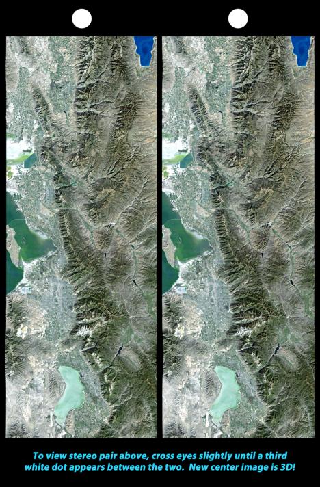
3D photo of the peaks on the north end of the Stansbury Mountain Range looking NW across the north end of Skull Valley. Black Mountain is visible in the distance. 

I began my ascent early in the morning while it was still dark. When the sun finally peeked over the Oquirrh Mountains, on the other side of the Tooele Valley, I took refuge out of the cold wind in a rocky nook where I soaked in the solar warmth and ate my pre-prepared meal of bison. The view was spectacular.
When I reached the the triangulation station, I found the target broken and laying on the ground. A broken cross-section was still in place and the pile of rocks that we used to secure the wooden ten-foot tall 2x4 were still there but somewhat displaced. 
Over time, the guy wire we had used to secure the target had rusted and failed. Rust stains have become a permanent part of a large anchor that still had some thirty three year old guy wire wrapped around it. 

3D photo of dilapidated triangulation target looking west across Skull Valley.

I took the liberty of standing the old dilapidated target up by wedging the ten foot long 2x4 betwixt some large rocks. It isn't anchored with guy wire this time and probably won't last through the winter, but for now it can be seen from many miles away.
3D photo from top of Stansbury Mountains looking NW toward Stansbury Island on the Great Salt Lake.

The Stansbury Mountains are named for their original surveyor, Major Howard Stansbury, (1806-1863). 

US Interstate 80 crossing the alkali flats of the south shore of the Great Salt Lake, a few miles north of Grantsville.

Stansbury, and his party of surveyors, are credited with the first official survey of the Great Salt Lake from 1849 to 1851. He was the first person to determine that the Great Salt Lake is actually a remnant of a greater ancient lake that he called Lake Bonneville.

3D photo of Lone Rock in Skull Valley looking west from the top of the Stansbury Mountains.

Lone Rock** in Skull Valley, another important triangulation point, is an interesting and unusual rock formation that has become a popular destination for outdoor enthusiasts. 
Salt plant on the south shore of the Great Salt Lake where State Highway 196/Skull Valley Rd intersects US Interstate 80. Black Mountain in the distance.

Salt production is an obvious industry on the shore of the Great Salt Lake. There are also billions of Sea Monkeys out there. 

Other important resources are extracted from the mineral-rich lake including magnesium at US Mag and even nutritional supplements in the form of trace minerals at Trace Minerals Research.

3D photo from the top of the Stansbury Mountains looking west across Skull Valley.
3D photo of 3D camera apparatus.

Major Stansbury's legacy lives on in the island and mountains that claim his name, and the monuments that he erected on mountain peaks and valleys around the Great Salt Lake.

* The Triangulation Station is located at approximately 
40° 43' 39.30" N
112° 37' 53.80" W
These coordinates are not official USGS coordinates, but are accurate within seconds. 

** Lone Rock Coordinates 
40° 42' 32" N
112° 41' 04" W

Thursday, September 25, 2014

Great Salt Lake in 3D Part 5 - From Above

The Great Salt Lake can be explored by driving, riding, hiking and boating but the best way to experience the dynamics of the lake may be from above. 
The above 3d photo of the Great Salt Lake area is provided by NASA's Jet Propulsion Laboratory, (courtesy of US tax dollars). 
Looking west, the above photo depicts the southern most tips of Antelope Island and Stansbury Island; two of the largest islands on the Great Salt Lake. In the foreground is the swampland that is located to the east of Antelope Island. Stansbury Island can be seen in the background at the top of the photo. 
The colorful swampland of the Great Salt Lake is amazingly beautiful and can be best appreciated from above. 
Above - the southernmost shore of the Great Salt Lake. US Interstate 80, a major corridor for east-west interstate transit is traveled by millions of people every year. Tooele Valley is shown nestled at the base of the Oquirrh Mountains. 
Rio Tinto's 12,000 foot tall smoke stack is an easy landmark to spot from the ground and from the air. The Great Salt Lake Marina is also visible in this photo, as is US Interstate 80 and Highway 201 at the northernmost point of the Oquirrh Mountains. 
Antelope Island State Park is home to a large variety of wildlife including a Bison herd. The island can be accessed by automobile and is enjoyed by thousands of tourists annually. 
Google Earth is a new and fun way to explore the Great Salt Lake area. Sometimes images appear distorted, like in this image of the Rio Tinto smoke stack. 


Monday, August 11, 2014

Great Salt Lake in 3D Part 4 - the Spiral Jetty

This post is the fourth in a series of articles exploring Utah's inland sea. When you see two similar images side-by-side, the photos can be viewed in 3D by gently crossing the eyes until both images become one. It's EZ to see 3D. 

Symbols are powerful things. In the past century, the Northern region of the Great Salt Lake has become a place of symbolic significance. Historically, it is the physical spot that linked the United States by rail. The driving of the Golden Spike at Promontory, UT, symbolized the realization of a truly United States. 
Today, the telegraph lines are silent and the tracks are empty most of the time except for daily reenactments during tourist season.


Our two and a half hour drive to the Spiral Jetty provided great views of the barren landscape of the Great Basin. Big sky, open road and acres and acres of acres and acres. Suddenly, there was a sign that indicated there was a rocket display ahead. Who can resist a good rocket display? As a former rocketeer, I could not. 


The display* was only a couple of kilometers out of our way and turned out to be well worth the excursion... and it felt good to stretch our legs after being couped up in the coup for a couple of hours. 


For decades, Thiocol has participated in the development of rockets used militarily and for space exploration. 


There are dozens of rockets, engines and parts of all sizes on display and a nice walkway provided so that visitors can browse freely and view them up close.


As we neared the Spiral Jetty, remains of pierworks and oil wells that once operated here could be seen. Oil was found floating on the briny water when pioneers first arrived in the region in the nineteenth century. Under pressure, the black crude oil oozes up through natural fissures and makes its way to the surface. When petroleum became profitable, the region was exploited for a brief time then abandoned due to lack of cost effectiveness and difficult drilling conditions. 


A few hundred yards to the west of the oil wells is where Robert Smithson chose to install his spectacular Spiral Jetty.*

The recent drought has lowered the lake to record levels and the receding shoreline is now several hundred feet from Smithson's counterclockwise spiraling earthwork of black basalt rocks. The Spiral Jetty was  constructed in 1970 and has become part of the landscape. The landmark only recently reappeared, after spending most of its life submerged.


Smithson selected a symbol that adorns the landscape and taps into man's primordial psyche. The region itself has prehistoric aura and is pretty much the same as it has been since the ancient Lake Bonneville receded to this level twelve thousand years ago. 
Sunsets are always spectacular over the Great Salt Lake and really enhanced our trip to the Jetty. 


One thing that made a huge impression on us was how silent this place is. The porous basalt rocky terrain in league with an endless shoreline of flaky salt crystals seems to absorb most of the natural ambient sound.


Visitors should know that there is no place to camp near the Spiral Jetty and there are no restroom facilities there either.  

The coordinates for the Rocket Display 
41° 39' 32.32" N 112° 26' 27.35" W

Spiral Jetty Coordinates
 41° 26' 15.66" N 
112° 40' 08.12 W

Tuesday, July 1, 2014

Great Salt Lake in 3D Part 3 Black Rock

This post is the third in a series of articles exploring Utah's inland sea. When you see two similar images side-by-side, the photos can be viewed in 3D by gently crossing the eyes until both images become one. It's EZ to see 3D. 

This time our explorations of Utah's salty inland sea took us to where Interstate 80 meets State Highway 201 - where the Oquirrh Mountains meet the Great Salt Lake. 


Black Rock* is no doubt one of the most familiar iconic features anywhere on the Great Salt Lake. Millions of travelers have noticed it from the highway as they passed by. Historically, it has been a place where pretty much every pioneer party stopped to rest. These days, Black Rock doesn't receive many visitors other than local litter bugs and shameless graffiti artists.
It's hard to believe that at one time there was even a popular resort that was frequented by travelers and locals alike. Today, receding waters reveal old rotting pilings, the remnants of the old piers - ghostly shadows of what this place once was.  
Black Rock is usually surrounded by water, but the recent drought has lowered the water level considerably. When Captain Howard Stansbury surveyed this region in 1850, his team took a boat to Black Rock where they constructed a timber triangulation station atop the highly visible landmark.  
The ill fated Donner Party stayed here and carved their names in the wall of nearby Black Rock Cave. If you know where to look, the cave can be seen looking southwest at the base of some cliffs.  
The cave** can be viewed more easily from the scenic view exit located between State Highway 201 exchange and exit 99 on Interstate 80. The entrance is mostly obscured by a mound of dirt, part of which came from an incident when the former land proprietors attempted to cover the entrance. Fortunately, a local preservation activist seated himself on the cliffs above the cave and prevented the dozer from covering the entrance entirely. Unfortunately, Black Rock Cave is on private property and inaccessible to the public.

Next time, we travel all the way to the Northern tip of the lake to visit the famous Spiral Jetty. See ya there!

* Black Rock GPS coordinates
40° 43' 29.96" N 112° 13' 39.70" W

** GPS coordinates for Black Rock Cave 
40° 42' 34.10 N 112° 14' 28.39" W

Sunday, June 22, 2014

Great Salt Lake in 3D Part 2 Stansbury Island

This post is the second in a series of articles exploring Utah's inland sea. When you see two similar images side-by-side, the photos can be viewed in 3D by gently crossing the eyes until both images become one. It's EZ to see 3D.  
On Saturday, we trekked to the northern most point of the Stansbury Mountain Range then continued north to Stansbury Island. 
Our first stop at the Stansbury Mountains was this little natural hot spring at the base of the mountain. Hot springs are common in the area and the temperature and salinity vary from pool to pool. Nearby Bonneville Seabase, hosts a variety of colorful tropical fish who thrive in the geothermally heated and salty pools.
A few feet from the hot spring we found this carcass of an unfortunate victim of this unforgiving environment. 
Large stones aligned North and South along the old Lincoln Highway. The largest is more than 5' tall. 
Leaving the Stansbury Mountains, we passed beneath Interstate 80 and headed to Stansbury Island, traveling northward, across the unpaved causeway, passed small salt flats until water is on both sides of the road
This valve allows the briny water to fill an evaporation pond. When the water has all evaporated, the salt will be collected and processed for use at your dinner table. Good eatin'
We found this old corral near the northeast shore of the Island. 
On this occasion, the water had an obvious pink hue that these photos don't do justice to. 
We found these salty birds hanging out on the salt plastered shoreline. 
Standing on the shore of this part of the Great Salt Lake is like being on another planet. No wonder the creators of Gentleman Broncos selected Stansbury Island as a primary location to film several pseudo sci-fi scenes. 

Much of the Great Salt Lake falls inside Tooele County, a region known for its diversity and uniqueness. No one knows for sure where the word, Tooele, comes from. It has been suggested that it is a Native American word that describes where land, air and sky meet... a mystical gateway to other dimensions. 
 The white salt and pink water is quite surreal. The birds seem almost out of place. 

 Looking south from the northwest end of Stansbury Island. 

The view along the causeway that leads from Stansbury Island to Bird Island. There is no access to Badger Island because the road is controlled by USA Magnesium.

Next time we'll explore Black Rock Beach and a nearby cave where the Donner Party camped.